


Google Maps is gaining a lot of features in recent times. And this might also be because of Google’s focus on its Maps product after Google I/O 2019. As a result, there is a lot of useful feature coming to Google Maps which benefit the users.
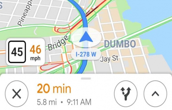
Recently, Google Maps saw the addition of features in navigation for local transports such as bus, trucks and other modes. Now, we have a new feature inside Google Maps called on-screen speedometer. We know that a speedometer shows the current speed of a vehicle that you are traveling in.
The on-screen speedometer does exactly the same for you but inside the Google Maps app. This comes in handy for you when you want to see the speed of a vehicle you are traveling in. This will give you an idea of the speed as well as the speed limit for that road. Apart from that, there is a new feature inside Google Maps which shows you if there are any natural disasters on the route where you are going.
If it finds any natural disasters such as earthquake, landslides, flash floods or something that you might not be aware of, it will take you to an alternate route. This will avoid the problem of getting stuck and make you aware of the issue through alerts at the same time. Google says that this feature is an expansion of their SOS feature which is already present inside Maps.
Currently, we are aware that the rollout of this feature inside Google Maps is a slow one. Also, this is a server-side update so you don’t have to update your app for this feature to work.
This feature is currently rolling out to users in Countries such as India, U.S. and the UK including others in batches. Once the feature comes to your device, you will see a speedometer in the Google Maps navigation screen.